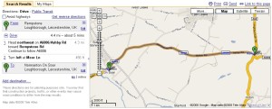
Click image to see larger map
I have noticed that, on the whole, my ancestors did not move around a great deal and tended to marry people who lived within a 10 mile radius of their home. While this isn't always the case, this knowledge can be useful when it comes to finding alternative locations to search for information. The problem is, sometimes my family lived in places I'm not familiar with, so even if I know they lived in Village A, but I find a record of their marriage in Village B, it isn't immediately obvious that I have found the correct people. This is when Google Maps can be very useful. Not only is it a great way to find and explore the home towns of our ancestors, it also features a route finding tool which shows you the exact distance between two or more locations.
The map above shows the results of a search I made for the distance between Rempstone and Normanton on Soar which are in Nottinghamshire and Leicestershire. Several branches of my family came from these villages, but because they are in different counties, I was initially unsure that the families were connected. However, as you can see, the two places are less than five miles apart.
Using distance as a way of eliminating incorrect results isn't foolproof. Sometimes people did travel very long distances but in my experience these tended to be people who had a good reason to do so, for example: soldiers, sailors and journeymen. Farmers, on the other hand, tended to stay close to home. Therefore, distance can be helpful but only when combined with other known facts.


No comments:
Post a Comment